Image versions and corrections
Improve image quality and geometry while keeping the original available for comparison. Destriping, cross-track equalization, ISOFIT atmospheric correction, and orthorectification each create a separate image version. Explorer groups related images under N versions.
Independent correction versions and version grouping are part of the 0.100 release candidate. See release availability.
Choose the operation
| Operation | Input | Result |
|---|---|---|
| Destriping / cross-track correction | Radiance before orthorectification | Separate radiance image on the same grid |
| Atmospheric correction (ISOFIT) | Calibrated at-sensor radiance with geographic metadata, before orthorectification | Separate surface-reflectance image |
| Create orthorectified version | Sensor-grid image with matching image-geometry map (IGM) | Separate image on a geographic grid |
Each submission performs the selected operation. ISOFIT does not implicitly destripe or orthorectify the image. If all three are needed, create corrected radiance first, use that version for ISOFIT, then orthorectify the desired radiance or reflectance version.
Changing a processing-level label does not perform these operations. See Process hyperspectral data for dark, camera-calibration, and white-reference workflows.
Create corrected radiance
- In Explorer, select the intended image version and confirm its active data layer is Radiance.
- Right-click the source and select Destriping / cross-track correction….
- Enable Remove detector stripes, Equalize cross-track illumination, or both.
- Choose whether detector positions run across Columns or Rows.
- Set Profile window (pixels) to an odd integer from 3 to 501.
- Select Create corrected version and follow Jobs.
Equalization can flatten real scene gradients as well as unwanted illumination variation. Compare with the original before using the output for analysis. Provider products may already be corrected; review their provenance first.
Create surface reflectance with ISOFIT
- Select a calibrated radiance version that has not been orthorectified.
- Right-click its source and select Atmospheric correction (ISOFIT)….
- Confirm the Input layer. The dialog reports images that lack radiance, geographic data, or suitable geometry.
- Optionally enable Water vapor presolve for the initial retrieval.
- Select Run correction and follow Jobs. For several eligible images, the button identifies the number of images to process.
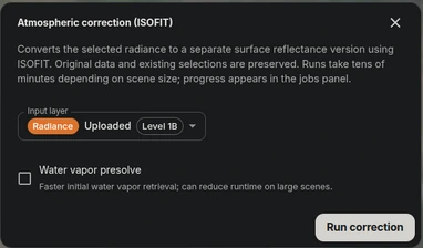
Confirm the radiance input and choose whether to run Water vapor presolve before starting atmospheric correction.
The selected layer must have the required ENVI header. Geographic bounds or STAC metadata supply scene context; they do not establish radiometric calibration. ISOFIT can take tens of minutes depending on the scene and available resources. A queued job is not a completed correction.
Create an orthorectified version
- Import the sensor-grid image with its matching IGM header and data pair.
- Select the image version and data layer to reproject.
- Right-click its source and select Create orthorectified version.
- Follow Jobs, then inspect the new version on a Map canvas.
The operation requires sensor geometry and a matching IGM. It changes the spatial grid; it does not perform atmospheric correction. Run radiance corrections before this step because those actions are unavailable on an already orthorectified version.
Compare and use versions
Expand N versions to select the original or a derived image. Each has its own source row and data layers. Selecting a version determines which image subsequent analyses use; publication preserves your existing selection.
For a workflow that needs all three operations, compare these stages:
| Version | What to review |
|---|---|
| Original radiance | Provider calibration, detector artifacts, and sensor geometry |
| Corrected radiance | Stripe reduction and preservation of real scene gradients |
| Surface reflectance | Spectral plausibility against suitable reference data |
| Orthorectified image | Geographic alignment and the effects of reprojection |
The stages are an example sequence. Use only the operations your source and application require; orthorectification can use radiance or reflectance.
Inspect processing level, correction description, wavelengths, sensor, and geometry before generating a composite, assigning dataset images, or running inference. Matching processing-level names do not guarantee matching units or provenance. Generate a composite for the new version if it has no visible result yet.
If a job fails, inspect its message before retrying. Report the image, input layer, operation, and job identifier to support when needed. Validate spectra and spatial alignment against suitable reference data; successful generation alone does not establish scientific accuracy.